Piri Reis
Map of the Western Part of the City of Venice
late 11th century AH/AD 17th century-early 12th century AH/AD 18th century (Ottoman)
W.658.186A
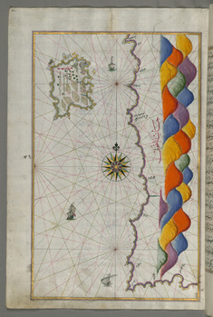
Leaf from Book on Navigation
late 11th century AH/AD 17th century-early 12th century AH/AD 18th century (Ottoman)
W.658.186B
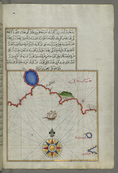
Leaf from Book on Navigation
late 11th century AH/AD 17th century-early 12th century AH/AD 18th century (Ottoman)
W.658.220A
Leaf from Book on Navigation
late 11th century AH/AD 17th century-early 12th century AH/AD 18th century (Ottoman)
W.658.221B
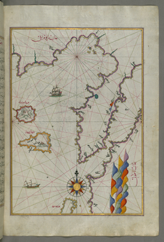
Leaf from Book on Navigation
late 11th century AH/AD 17th century-early 12th century AH/AD 18th century (Ottoman)
W.658.245A
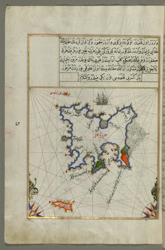
Leaf from Book on Navigation
late 11th century AH/AD 17th century-early 12th century AH/AD 18th century (Ottoman)
W.658.246B
Leaf from Book on Navigation
late 11th century AH/AD 17th century-early 12th century AH/AD 18th century (Ottoman)
W.658.263B
Leaf from Book on Navigation
late 11th century AH/AD 17th century-early 12th century AH/AD 18th century (Ottoman)
W.658.264A
Leaf from Book on Navigation
late 11th century AH/AD 17th century-early 12th century AH/AD 18th century (Ottoman)
W.658.265B
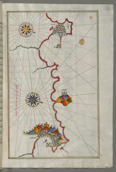
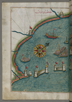
Map of the Algerian Coast From Algiers to Bejaia
late 11th century AH/AD 17th century-early 12th century AH/AD 18th century (Ottoman)
W.658.271B
Leaf from Book on Navigation
late 11th century AH/AD 17th century-early 12th century AH/AD 18th century (Ottoman)
W.658.288A
Leaf from Book on Navigation
late 11th century AH/AD 17th century-early 12th century AH/AD 18th century (Ottoman)
W.658.289B
Leaf from Book on Navigation
late 11th century AH/AD 17th century-early 12th century AH/AD 18th century (Ottoman)
W.658.301A
Leaf from Book on Navigation
late 11th century AH/AD 17th century-early 12th century AH/AD 18th century (Ottoman)
W.658.302B
Leaf from Book on Navigation
late 11th century AH/AD 17th century-early 12th century AH/AD 18th century (Ottoman)
W.658.304A
Leaf from Book on Navigation
late 11th century AH/AD 17th century-early 12th century AH/AD 18th century (Ottoman)
W.658.305B
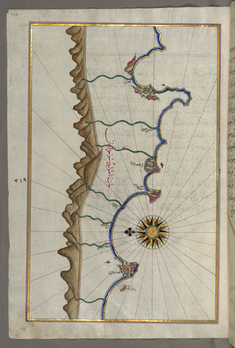
Map of the Anatolian Coast as Far as Alanya
late 11th century AH/AD 17th century-early 12th century AH/AD 18th century (Ottoman)
W.658.328A
Leaf from Book on Navigation
late 11th century AH/AD 17th century-early 12th century AH/AD 18th century (Ottoman)
W.658.329B
Leaf from Book on Navigation
late 11th century AH/AD 17th century-early 12th century AH/AD 18th century (Ottoman)
W.658.351A
Leaf from Book on Navigation
late 11th century AH/AD 17th century-early 12th century AH/AD 18th century (Ottoman)
W.658.352B
Leaf from Book on Navigation
late 11th century AH/AD 17th century-early 12th century AH/AD 18th century (Ottoman)
W.658.370A
Map of the City of Istanbul, from Book on Navigation by Piri Reis
late 11th century AH/17th century AD-early 12th century AH/18th century AD (Ottoman)
W.658.370B
Map of the Coastline of the Black Sea
late 11th century AH/AD 17th century-early 12th century AH/AD 18th century (Ottoman)
W.658.371B
Map of the Crimea, the Sea of Azov, and the Mouth of the Dnieper
late 11th century AH/AD 17th century-early 12th century AH/AD 18th century (Ottoman)
W.658.372A
Leaf from Book on Navigation
late 11th century AH/AD 17th century-early 12th century AH/AD 18th century (Ottoman)
W.658.373B
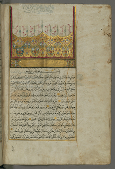
Illuminated Headpiece and Frame
late 11th century AH/AD 17th century-early 12th century AH/AD 18th century (Ottoman)
W.658.4B
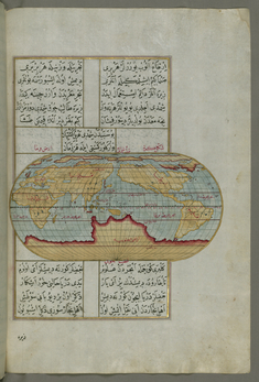
Oval Map of the World
late 11th century AH/AD 17th century-early 12th century AH/AD 18th century (Ottoman)
W.658.23B
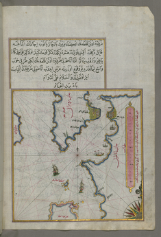
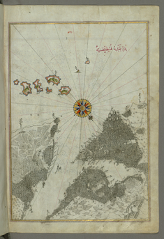
Map of the Upper Aegean Sea with the Islands of Imbros and Bozca
late 11th century AH/AD 17th century-early 12th century AH/AD 18th century (Ottoman)
W.658.39B
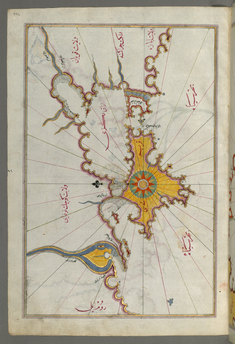
Map of the Island of Bozjah (Tenedos) Off the Coast of Anatolia
late 11th century AH/AD 17th century-early 12th century AH/AD 18th century (Ottoman)
W.658.43A
Map with Part of the European Coastline with the Islands of Semendrek and Imroz in the Aegean Sea
late 11th century AH/AD 17th century-early 12th century AH/AD 18th century (Ottoman)
W.658.45B
Map of the Islands of Semendrek and Imroz in the Aegean Sea
late 11th century AH/AD 17th century-early 12th century AH/AD 18th century (Ottoman)
W.658.44B
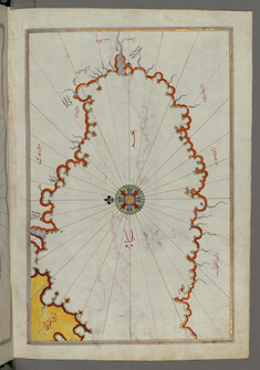
Map of the Island of Lemnos
late 11th century AH/AD 17th century-early 12th century AH/AD 18th century (Ottoman)
W.658.47A